


Bassin des Marquisades

PascalBanide
User
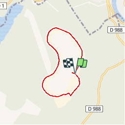

Length
5.1 km

Max alt
404 m

Uphill gradient
54 m
Km-Effort
5.8 km

Min alt
380 m

Downhill gradient
49 m
Boucle
Yes
Creation date :
2019-08-11 09:44:46.695
Updated on :
2019-08-11 09:45:58.328
1h16
Difficulty : Easy

FREE GPS app for hiking
 SityTrail
IGN / Geographical institutes
SityTrail Plus
The world is yours!
About
Trail Walking of 5.1 km to be discovered at Grand Est, Ardennes, Les Mazures. This trail is proposed by PascalBanide.
Description
Randonnée très facile
Positioning
Country:
France
Region :
Grand Est
Department/Province :
Ardennes
Municipality :
Les Mazures
Location:
Unknown
Start:(Dec)
Start:(UTM)
617063 ; 5530086 (31U) N.
Comments